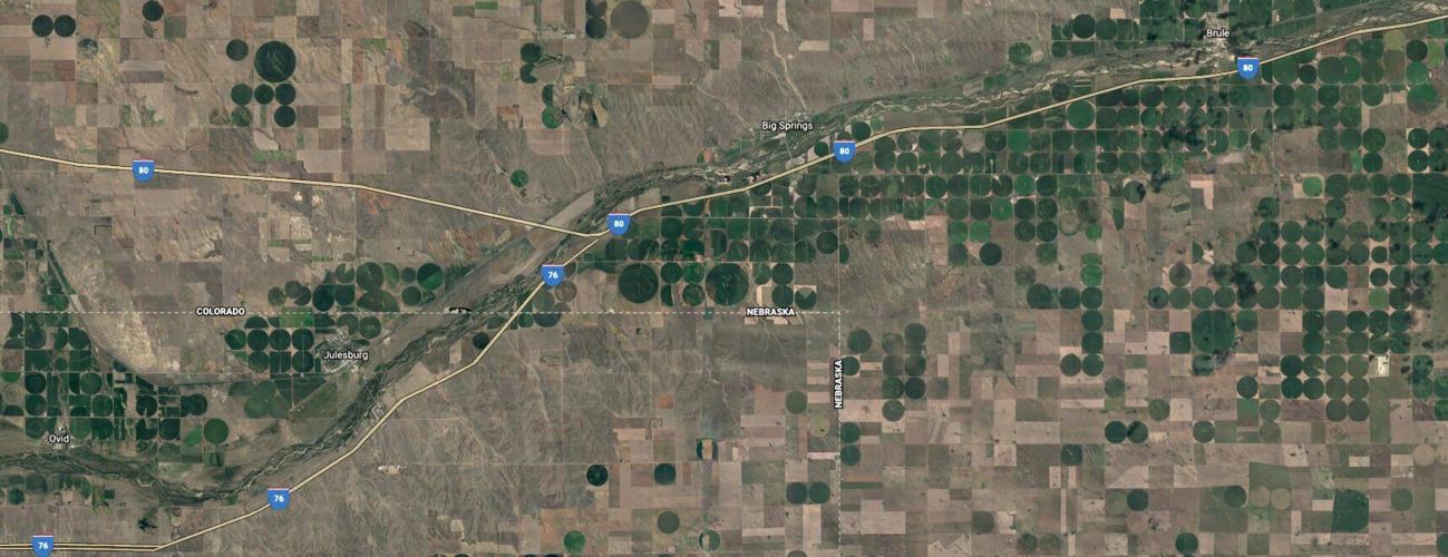
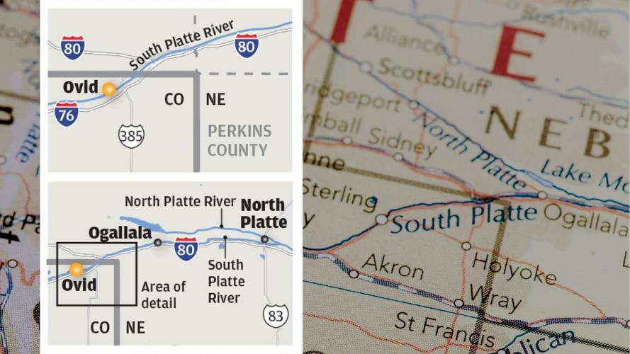
It seems to be a striking proposal: That Nebraska could use eminent domain in Colorado and build a canal that diverts water from the South Platte River for irrigation in Nebraska.
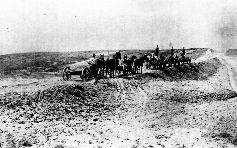
People work on the Perkins County Canal in the 1890s. The project eventually was abandoned due to financial troubles. But remnants are still visible near Julesburg.
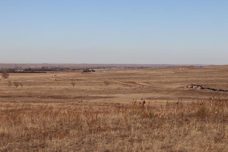
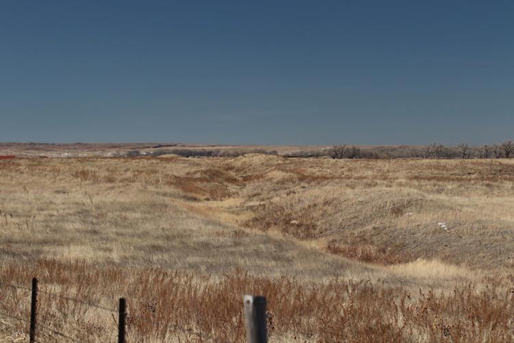
The eroded hillside cut at right is part of the easternmost remnants of the original 1894 excavation for the abandoned Perkins County Canal in Sedgwick County, Colorado. This photo looks toward the South Platte River valley and Nebraska from the east edge of the Julesburg Cemetery, located in the southeast quadrant of the Interstate 76-U.S. Highway 385 interchange south of Julesburg, Colorado.
Governor Pete Ricketts delivered the state of the state address on Thursday in Lincoln.
Photos: National landmarks of Nebraska
Pony Express National Historic Trail
Don Parmenter, left, of Gering and Casey Debus of Morrill wait momentarily at Scotts Bluff National Monument while the mochila transfers horses. In 2008, the two riders participated in a Pony Express re-ride that began in Sacramento, California, and concluded in St. Joseph, Missouri.
ROGER HOLSINGER/WORLD-HERALD NEWS SERVICE
The Willow Island Pony Express station
The Willow Island Pony Express station sits in a city park in Cozad, Neb. First used as a trading post, the station also served as a stage coach stop for the Central Overland California and Pikes Peak Express Company. The cabin was originally built on a bank of the Platte River, south of present-day Darr, Neb., and was moved here in 1938.
DAVID HENDEE/THE WORLD-HERALD
Pony Express National Historic Trail & Oregon National Historic Trail
Markers south of exit 231 on Interstate 80, between Lexington and Cozad, designate the nearby sites of the Willow Island Pony Express station, left, and the Oregon Trail.
DAVID HENDEE/THE WORLD-HERALD
Ash Hollow State Historical Park
Trail riders move down the Oregon Trail at Ash Hollow State Historical Park during the Convergence on Sacred Ground event in 2017. In full, the Oregon Trail spanned over 2,000 miles and crossed six states, in which trail landmarks, settlements, wagon ruts and other traces can still be seen today.
DAVID HENDEE/THE WORLD-HERALD
Oregon National Historic Trail
The Oregon Trail Wagon Train passes over a bed of white "plains bee balm" on the first day of a four-day trek. Once a popular tourist attraction, participants were able to experience a little of what the pioneer journey over the prairie near Chimney Rock was like.
BILL BATSON/THE WORLD-HERALD
Scotts Bluff National Monument
For both Native American tribes and pioneers traveling westward, Chimney Rock, now a National Historic Site near Bayard, was the first of two important markers along the Oregon, Mormon, and California trails in the Nebraska Panhandle. The unique geological formation, along with the landmark at Scotts Bluff National Monument, less than thirty miles away, appears mentioned in the writings of many early settlers.
RYAN SODERLIN/THE WORLD-HERALD
Scotts Bluff National Monument
Evening light and rolling storm clouds create a scenic backdrop for the prairie landscape at Scotts Bluff National Monument. The monument marks its 100th anniversary this year.
RYAN SODERLIN/THE WORLD-HERALD
Farm and Ranch Museum
Max Cawiezel operates an antique John Deere sugar beet digger with the help of Belgian horses Bob and Ben at the Farm and Ranch Museum near Gering, Neb. Historical equipment and farming techniques were a part of the museum's eighth annual Harvest Festival in 2004.
RICK MYERS/WORLD-HERALD NEWS SERVICE
Homestead National Monument of America
The Homestead Act of 1862 offered incentive, in the form of 160 acres of free land, to pioneers moving westward. Homestead National Monument commemorates this historic event, housing an extensive collection of homesteading artifacts and offering interactive exhibits documenting the lives of early settlers. On display here is a 1945 Allis Chalmers Model C tractor, used in Alaska on the nation's last homestead.
DAVID HENDEE/THE WORLD-HERALD
Homestead National Monument of America
In August 2017, a rare total solar eclipse crossed a wide swath of Nebraska, bringing with it record amounts of tourism to small towns and state parks along the path. Bruce Cardwell, center, of Omaha, Nebraska, waits for the eclipse to reappear from behind the clouds. Homestead National Monument hosted a viewing party for the eclipse, inviting NASA scientists and featuring programs led by celebrity guest Bill Nye.
RYAN SODERLIN/THE WORLD-HERALD
Homestead National Monument's Homestead Heritage Center
The sky over the Homestead National Monument's Homestead Heritage Center is illuminated by a lunar eclipse on Jan. 31, 2018, as seen through the window of the center. Open prairie and clear skies have made the site popular for star viewing and storytelling, as well as daytime astronomy programs.
RYAN SODERLIN/THE WORLD-HERALD
Mormon Pioneer National Historic Trail
The Mormon Pioneer National Historic Trail traces the path of early Mormon settlers from Illinois, through Iowa and Nebraska, towards Wyoming and Utah. Two notable encampment areas — Winter Quarters in north Omaha and Kanesville in Council Bluffs — served as vital stops along the way.
CHRIS MACHIAN/THE WORLD-HERALD
Mormon Pioneer National Historic Trail
Amber Lutke, left, and Russ Leger lead a wagon train on Pioneer Trail heading to for the Grand Encampment at the Iowa School for the Deaf in Council Bluffs. The event marked the 170th anniversary since the Mormons left Nauvoo, Illinois, to camp in what are now Council Bluffs and north Omaha.
CHRIS MACHIAN/THE WORLD-HERALD
California National Historic Trail
Dave McKeag, trail boss and wagonmaster from Council Bluffs, prepares to lead the 150th anniversary Gold Rush Days wagon trail ride to California. The ride started from the Western Historic Trail Center in Council Bluffs, and included a stop overnight in Omaha.
RUDY SMITH/THE WORLD-HERALD
Missouri National Recreational River
The Missouri River, as seen from the Chief Standing Bear Bridge connecting Nebraska and South Dakota, near Niobrara on the Lewis & Clark trail. Two segments of the river, totaling just over one hundred miles, make up the Missouri National Recreational River.
JEFF BEIERMANN/THE WORLD-HERALD
Lewis & Clark National Historic Trail
The Lewis and Clark replica keelboat of The Discovery Expedition of St. Charles, Missouri, pushes up the Missouri River across from downtown Omaha. As part of the 200th anniversary celebration of the Lewis & Clark Expedition, reenactors followed the original route of the expedition up the river, stopping at several cities along the way.
JEFF BEIERMANN/THE WORLD-HERALD
Niobrara National Scenic River
Rapids attract visitors to the Niobrara River's Rocky Ford area. Only a fraction of segments of rivers in the United States are able to be designated under the National Wild & Scenic Rivers System - the 76-mile stretch near Valentine qualifies by being a free-flowing segment with accessible undeveloped shoreline and clean or managed water. Rocky Ford, a popular take-out site for canoes and float trips, is privately owned, but past negotiations have considered turning it over to the federal government to ensure continued public access.
MEGAN FARMER/THE WORLD-HERALD
Niobrara National Scenic River
Members of the University of Nebraska-Lincoln Wildlife Club take canoes and kayaks out on the Niobrara River.
CHRIS MACHIAN/THE WORLD-HERALD
Niobrara National Scenic River
The Niobrara National Scenic River is also home to nationally and regionally significant geology, fossil sites and wildlife. Diverse species of plants and animals, including elk, can be found at the Niobrara National Wildlife Refuge.
CHRIS MACHIAN/THE WORLD-HERALD
Agate Fossil Beds National Monument
This bock of fossils was collected from the Agate Fossil Beds National Monument and is housed in the American Museum of Natural History in New York City. It contains bones from several different groups of animals, including chalicotheres, giant pigs, oreodonts, cats and dogs. Most of the bones, however, are from Menoceras, a pony-sized rhinoceros.
WORLD-HERALD NEWS SERVICE
Agate Fossil Beds National Monument
Sunset shadows at Agate Fossil Beds National Monument.
People work on the Perkins County Canal in the 1890s. The project eventually was abandoned due to financial troubles. But remnants are still visible near Julesburg.
The eroded hillside cut at right is part of the easternmost remnants of the original 1894 excavation for the abandoned Perkins County Canal in Sedgwick County, Colorado. This photo looks toward the South Platte River valley and Nebraska from the east edge of the Julesburg Cemetery, located in the southeast quadrant of the Interstate 76-U.S. Highway 385 interchange south of Julesburg, Colorado.


