LEMOYNE — Folks in Keith County don’t need to look up recent statistics to know Lake McConaughy is flirting with historic low levels.
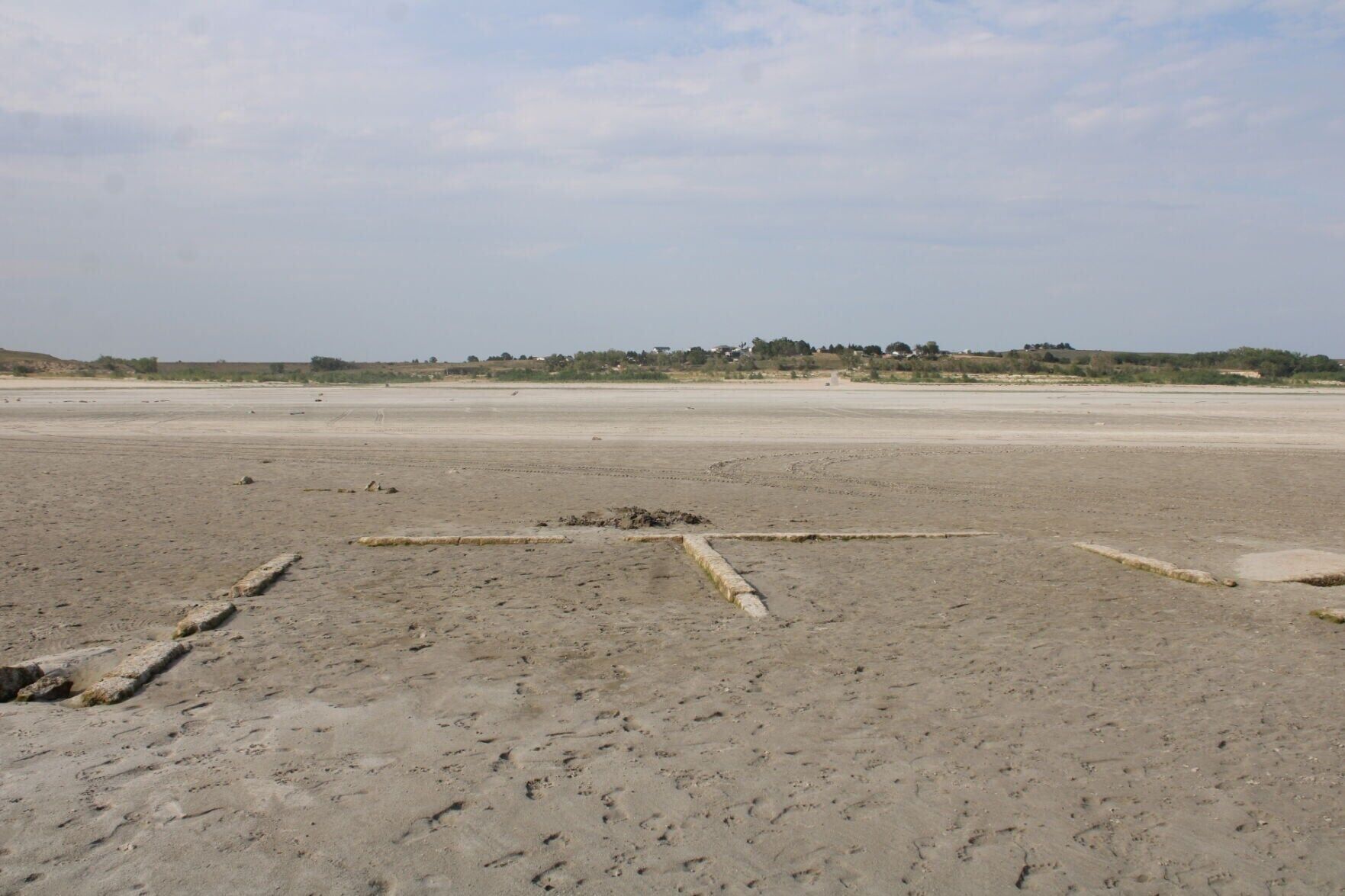
It’s obvious from the re-emergence of “Old Lemoyne,” the ruins of the north-shore settlement’s original 1911 location that last were visible in 1956 and 2004.
![]()
This foundation remnant from the original 1911 Lemoyne town site
points toward the Lake McConaughy shoreline settlement’s post-1941
location on bluffs two miles north at the edge of the North Platte
River valley in Keith County. The “Old Lemoyne” ruins have
re-emerged from the shrinking lake for just the third time in the
85 years since the completion of Kingsley Dam.
TODD VON KAMPEN, THE NORTH PLATTE TELEGRAPH
With Lake Mac so low, the ghosts of Old Lemoyne speak again
It’s not quite as low — yet — as in those two years when drought and downstream irrigation drained Lake Mac to the lowest points since its birth after Kingsley Dam’s 1941 completion.
McConaughy stood at 3,203.7 feet of elevation Wednesday, 20 feet below a year ago and 5½ feet above its record low of 3,197.5 feet on Sept. 14, 2004. It bottomed out at 3,198.2 feet from Oct. 17 to 19, 1956.
Even at its current 24.4% of capacity, McConaughy remains Nebraska’s largest lake. But as Labor Day weekend approaches, west central Nebraskans wonder whether the state’s top outdoor attraction is certain to fall to its lowest level in 85 years.
“That is a million-dollar question,” said Devin Brundage, general manager of the Central Nebraska Public Power and Irrigation District that built Kingsley and owns Lake Mac’s 22-mile-long footprint.
He said Tuesday that 2026’s spring and summer weather pattern “mimics last year a little bit,” when the western Plains also had “a super-dry spring.”
But though Central’s peak irrigation season has two weeks to go, Brundage said, recent timely rains have “let us back off the irrigation allocations” to the district’s prime “Tri-County” users in Gosper, Phelps and Kearney counties.
“The same thing saved us last year,” he said. “We got the late rains, and we popped back up to 50% capacity.”
But if the rains stop again, “we could make it” to the record low, he added.
Labor Day warnings
Boaters eyeing Lake Mac before and during the Labor Day weekend should avoid traveling west of Van’s Lakeview — across the lake roughly south-southwest of Lemoyne — to avoid the risks of getting stuck in mud, the Nebraska Game and Parks Commission advised in a press release this week.
The last of McConaughy’s public boat ramps has been closed due to the receding water levels, though Van’s (308-287-8267), Ski Patrol (308-726-7368) and Big Mac Marina (308-355-5555) provide launching services.
Farms, ranches and the towns of Lemoyne and Keystone occupied Keith County’s part of the North Platte River valley when leaders such as Charles W. McConaughy of Holdrege and George P. Kingsley of Minden eyed it a century ago to store water for their area’s farms.
Up to 1.74 million acre-feet of water can be stored behind the 3.1-mile-long dam that bears Kingsley’s name and was the world’s second-largest earthen dam when built from 1936 to 1941.
Besides the Tri-County region, Brundage said, McConaughy serves five irrigation districts in Lincoln and Dawson counties: the Dawson County, Cozad, Gothenburg and 30 Mile canals and the Orchard Alfalfa ditch.
Lake Mac also has been brim-full often in its 85 years. In July 2011, less than seven years after its 2004 low, it reached the 3,265-foot level that has been its general limit since a May 1, 1972, windstorm seriously damaged Kingsley’s face and caused evacuations of the town of Keystone below the dam.
The Federal Energy Regulatory Commission allows storage up to 3,270 feet at some times of year or by special permission at other times.
The Nebraska Legislature in 2022 approved a package of recreational improvements that included a new $30 million marina near the dam.
But Game and Parks called off the marina in 2025 — citing the lake’s fickle, irrigation-driven levels — and is focusing on improving local roads and adding more low-water ramps.
![]()
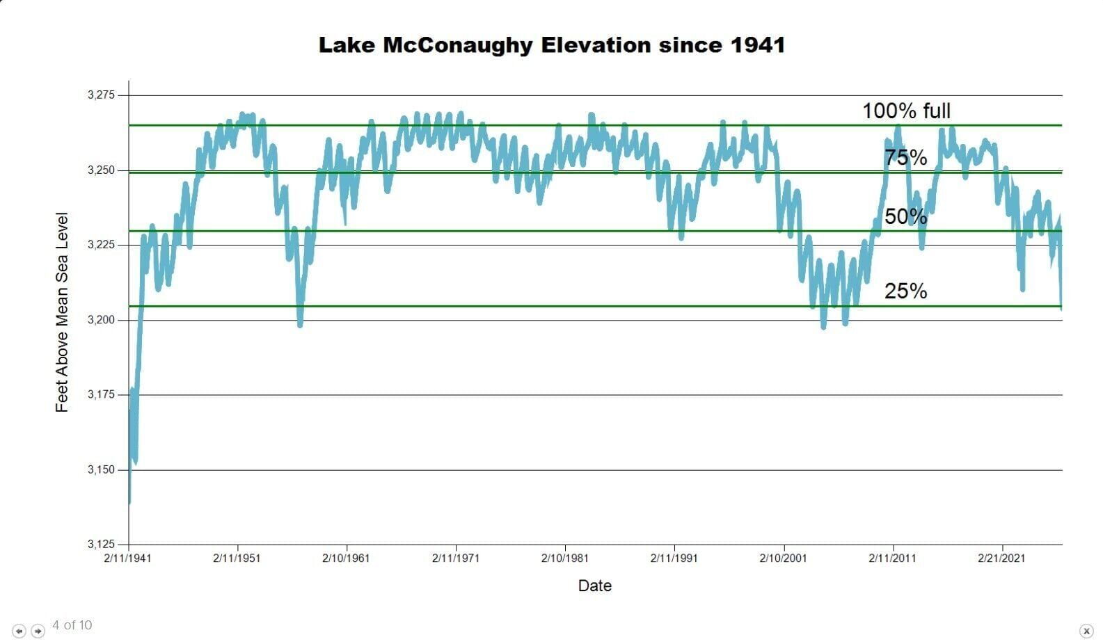
This table from the Central Nebraska Public Power and Irrigation
District website depicts Lake McConaughy’s water levels since
Kingsley Dam was completed in 1941. The “100% full” line represents
the 3,265-foot elevation that has been the general federally
imposed limit since a May 1, 1972, windstorm seriously damaged the
dam face. Storage levels can be as high as 3,270 feet at certain
times of year or with special permission from the Federal Energy
Regulatory Commission.
CENTRAL NEBRASKA PUBLIC POWER AND IRRIGATION DISTRICT
Low spring snowmelt
As in 1956 and 2004, Brundage said, upstream drought has been the major culprit behind Lake Mac’s dramatic decline. Snowpack levels were at just 27% of normal May 1 in the northern Colorado mountains that feed the North Platte and Laramie river basins.
He said McConaughy inflows greatly depend on “return flows” from the 1902 North Platte River Project, which stores irrigation water in seven Wyoming reservoirs for farmers in eastern Wyoming and the Nebraska Panhandle.
The older project also has been stressed by this year’s snowmelt shortages, Brundage said. But greater Panhandle groundwater use also has contributed to lessening upstream flows into Lake Mac over its lifespan.
The June releases of 90,000 af from the U.S. Fish and Wildlife Service’s Lake Mac “environmental account” played a lesser role in this year’s declines, Brundage said.
Set up as a condition of Kingsley’s 1997 relicensing, the EA reserves water for release downstream to scour central Nebraska’s Platte riverbed. The extra flow is meant to improve habitats for endangered or threatened bird species such as the least tern and piping plover.
But Brundage said Lake Mac’s water levels won’t be affected for two to three years by what will be the third major refacing in Kingsley’s history: an upcoming job, currently estimated to cost $250 million to $300 million, job to repair damage from 2021 and 2022 windstorms.
He said the dam is in better shape than it was after the 1972 gales, which required hundreds of trainloads’ worth of rock for repairs.
Access to the dam face has been restricted along a 10-foot-tall, north-to-south strip between 3,230 and 3,240 feet of elevation, he said. Repairs, when they begin, must start at the 3,220-foot-level.
But “today, we have no restrictions. We can fill the lake,” Brundage said. “We have not let a drop of water out in the last six to seven years that didn’t need to come out.”
He added that Tri-County irrigators remain under the same annual usage restrictions of 9 inches imposed after the 2004 drawdown, though they can purchase more water.
It also doesn’t take as much water to serve them as it used to, he said.
“Prior to the 2000s, we may have used 200,000 acre-feet annually to deliver to the 108,000 acres” in the three counties, Brundage said.
“Today, due to (canal) lining projects and conservation practices, we deliver (them) 150,000 acre-feet. … The changes that occurred there are long-lasting and permanent. They’re baked into the conservation.”